Astronaut photo shows the U.S. Midwest’s city lights under a glowing horizon
NASA's Earth Observatory published an ISS photo of the Midwest's city lights taken at 09:54 UTC on October 18, with green airglow on one side and sunrise light on the other.
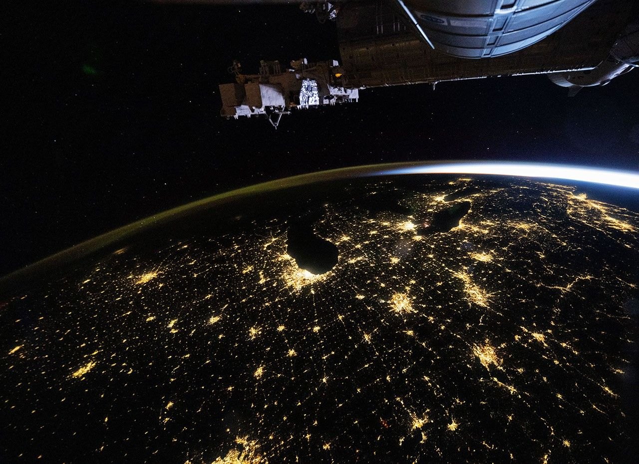
An astronaut on the International Space Station photographed the U.S. Midwest’s city lights from orbit at 09:54 UTC on October 18, 2026. NASA’s Earth Observatory published the image on November 4. Clear skies let the crew see cities from Chicago to Louisville.
Cities, highways and a glowing horizon
The photo was taken at 4:54 a.m. Central Daylight Time, with a Nikon Z9 camera and a 14-millimeter wide-angle lens. NASA says the Expedition 75 crew had an almost cloud-free view of much of the eastern United States.
The largest metropolitan areas, Chicago and Detroit, are among the brightest features. Mid-sized cities such as Indianapolis, Cincinnati and Louisville also stand out, linked by lines of light along state and interstate highways.
The horizon at the left shows a faint band of green and orange. This is airglow, a light the upper atmosphere gives off when sunlight strikes its atoms and molecules and makes them release photons, the particles of light. It is a different effect from the aurora, which is driven by charged particles from space. If you want the aurora instead, the northern lights forecast for tonight is the place to look.
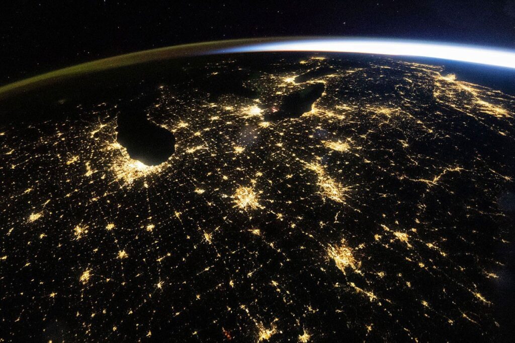
On the right, sunlight arcs along the horizon. Dawn was still roughly an hour off along the East Coast and two hours off over Chicago, according to NASA, which is why the ground below is still dark.
Why scientists keep photographing cities at night
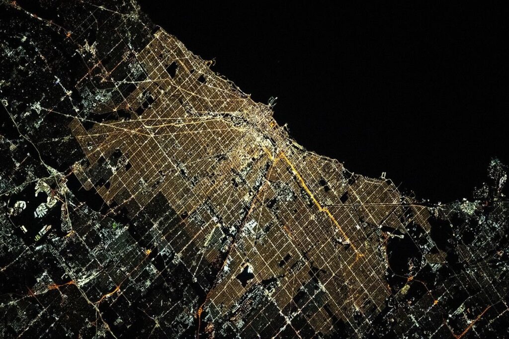
NASA says astronaut photos of nighttime lights help track changes in the built environment. In the wide view, Chicago looks a uniform pale yellow. A second photo, taken on March 1, 2024 by the Expedition 70 crew with a Nikon D5 and a 400-millimeter lens, shows a range of colors that come from different kinds of lighting.
Researchers have used NASA’s archive of astronaut photography, the Gateway to Astronaut Photography of Earth, to build a method that tells lighting types apart within the pixels of night photos. Measuring the brightness, color and extent of a city’s lights over time can show how it grows and changes, according to NASA.
Satellites do similar work. NASA’s Black Marble product suite turns satellite observations into science-quality records of nighttime lights at daily, monthly and yearly scales. In the eastern U.S., scientists have used it to follow power outages and recovery after major storms, lighting around new infrastructure, and the switch from older lighting to LEDs.
What a photo can show that a satellite cannot, and the reverse
The two methods complement each other, and the numbers explain why. According to NASA’s Earthdata page for Black Marble, the data come from the VIIRS instrument on U.S. weather satellites. Its Day/Night Band, the sensor that detects faint light at night, has a spatial resolution of 750 meters. Each pixel therefore covers a patch far larger than a street or a stadium car park.
A handheld camera on the ISS can zoom in much further. The 400-millimeter lens used for the 2024 Chicago photo resolves lighting color that a 750-meter pixel blends together. The tradeoff is coverage: astronaut photos are taken when a crew member has time and a clear sky, while the satellites record the whole globe on a regular schedule. Black Marble products are delivered in near real time, within a three-hour window, according to the same NASA page.
The satellite record also has a limit worth knowing. NASA’s Black Marble page says Suomi NPP, the first satellite in the series, launched in October 2011 and is no longer delivering new data, and that its final observations were scheduled to end on November 2, 2026. Newer NOAA-20 and NOAA-21 satellites, launched in November 2017 and November 2022, continue the record.
Sharper, color-aware views from the station help interpret what the satellite pixels average out. That matters most for LED conversions, which change a city’s color and brightness at the same time.
Taking such photographs is part of the daily routine for the crew; life aboard the International Space Station includes time set aside for Earth observation. NASA says the station program supports the work so that the images are of the greatest value to scientists and the public, and are freely available online. The photographs are ISS075-E-226709 and ISS070-E-105097. NASA says they were cropped and enhanced for contrast, and lens artifacts were removed. The story was written by Lindsey Doermann.