Mars pictures: The best photos from NASA rovers and orbiters, and what each one shows
From Perseverance's 96-image Falbreen panorama to the 1998 Face on Mars, these NASA pictures show how Mars looks, why its sunsets differ and how cold the surface gets.
Dates and facts checked on the official pages on October 21, 2026.
The best pictures of Mars come from NASA’s two working rovers, Perseverance and Curiosity, and from orbiters such as the Mars Reconnaissance Orbiter. The rovers show the ground at eye level, in panoramas that stitch dozens or even thousands of frames together. The orbiters show whole valleys and landforms from above.
The pictures below are all official NASA images, and each entry says when it was taken, with which camera and what it shows. Facts were checked against NASA pages on October 21, 2026.
Six Mars pictures worth knowing, from sunset to the Face
Each of these has an official catalog entry and a clear scientific story behind it.
| Picture | Taken by | Date taken | What it shows |
|---|---|---|---|
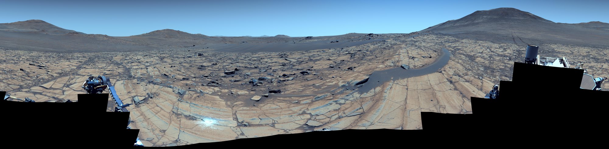
| Falbreen panorama | Perseverance, Mastcam-Z | May 26, 2025 (sol 1,516) | 360-degree view built from 96 images, with hills up to about 40 miles (65 km) away |
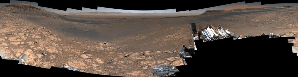
| 1.8-billion-pixel panorama | Curiosity, Mastcam | Nov. 24 to Dec. 1, 2019 | Clay-rich slopes of Mount Sharp, from more than 1,000 images |
| Boxwork patterns at a distance | Curiosity, Mastcam | May 22, 2025 (sol 4,536) | Low ridges that scientists link to ancient groundwater, 23 images |
| First Martian sunset | Perseverance, Mastcam-Z | Nov. 9, 2021 (sol 257) | A paler sunset than usual, because the air held less dust |
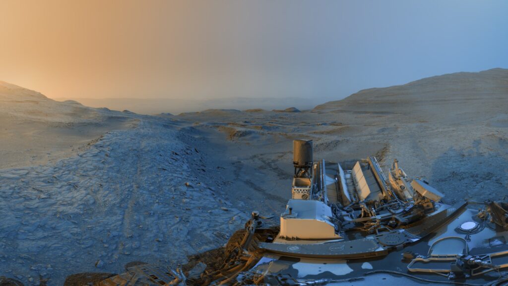
| Day-and-night postcard | Curiosity, black-and-white cameras | Nov. 18, 2025 (sols 4,722 and 4,723) | A ridge scene merging a 4:15 p.m. view and an 8:20 a.m. view |
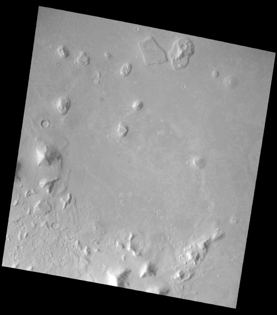
| Face on Mars | Mars Global Surveyor, Mars Orbiter Camera | April 5, 1998 | A landform in the Cydonia region, 4.3 meters per pixel |
Figures checked on NASA and JPL pages on October 21, 2026. A sol is one Martian day, which lasts 24.6 hours.

Perseverance’s Falbreen panorama shows hills 40 miles away
JPL described this as one of the sharpest views from the Perseverance mission. Its Mastcam-Z camera, a pair of zoom lenses on the rover’s mast, took 96 images on May 26, 2025. They were stitched into a full circle, and JPL released it on August 6, 2025.
The scene is a geology lesson. According to JPL, lighter rocks near the rover are rich in olivine, a green mineral common in volcanic rock, while darker, older clay-bearing rocks lie farther away. A boundary between the two units runs through the view. A large loose rock sits on a sand ripple about 14 feet (4.4 m) from the rover, and the rover’s tracks lead back to an earlier stop called Kenmore.
Two versions exist: natural color, where the sky looks reddish, and enhanced color, where it looks blue. Current positions and new frames from this rover are collected in the latest pictures from the Mars rovers Perseverance and Curiosity.
Curiosity’s 1.8-billion-pixel panorama is its sharpest view of Mount Sharp
Between Nov. 24 and Dec. 1, 2019, Curiosity captured its highest-resolution panorama of the Martian surface. NASA assembled it from more than 1,000 images over the following months and posted it in March 2020. The version without the rover contains nearly 1.8 billion pixels, and the version with the rover in view has nearly 650 million.
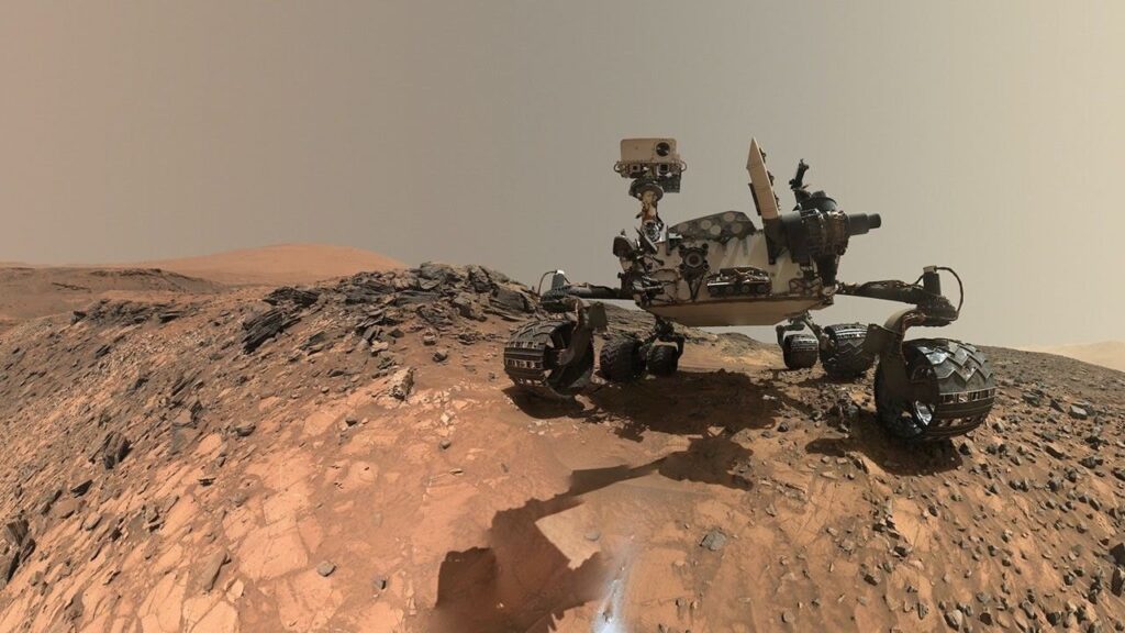
The scene is Glen Torridon, a clay-rich region on the flank of Mount Sharp inside Gale Crater. Malin Space Science Systems in San Diego built and operates the Mastcam camera that took the images.
Curiosity later climbed into a patch of low ridges called boxwork. A 23-image Mastcam panorama from May 22, 2025, with colors adjusted to approximate what a human eye would see on Earth, shows the pattern. Scientists believe groundwater formed these ridges billions of years ago. More on the mission is in the piece on the Curiosity rover on Mount Sharp.
A Mars sunset can look blue, and the first one Perseverance saw was paler than usual
Perseverance’s Mastcam-Z photographed its first Martian sunset on Nov. 9, 2021, the 257th sol of the mission. NASA notes that Martian sunsets are usually tinted blue because dust in the air scatters blue light. This one looks more muted because there was less dust than usual. NASA calibrated and white-balanced the color to remove camera artifacts.
A different kind of picture arrived in December 2025. Curiosity was told to photograph the same scene twice on Nov. 18, 2025: at 4:15 p.m. local Mars time on sol 4,722 and at 8:20 a.m. on sol 4,723. NASA merged the two black-and-white panoramas into one "postcard" and added color artistically, blue for the morning frame and yellow for the afternoon one. It is a designed image, not a single moment.
For how twilight clouds behave in the Martian autumn, see Curiosity’s first twilight clouds of a new Martian autumn.
The color of Mars depends on how the picture was processed
Mars looks red because iron in its rocks, soil and dust has oxidized, or rusted, according to NASA. Dust lofted into the air makes the planet look mostly red from far away.
Close up, the color in a rover picture is a choice. Teams publish natural-color versions, enhanced-color versions that exaggerate differences between rocks, and white-balanced versions that approximate Earth lighting. The Falbreen release shows this clearly: the same scene has a reddish sky in one version and a blue sky in the other. Captions state which was used, and that is the line to check before assuming a picture shows what a person standing there would see.
The Face on Mars is a landform photographed twice, 22 years apart in technique
The Face is a feature in the Cydonia region, at about 40.8 degrees north and 9.6 degrees west. NASA’s Viking Orbiter imaged it in the mid-1970s, and its low-resolution view, with its shadows, made it look like a face.
Mars Global Surveyor looked again. Its Mars Orbiter Camera imaged the feature on April 5, 1998, from 275 miles (444 km) away. At 14.1 feet (4.3 meters) per pixel, the new image was about ten times sharper than the best Viking view. The frame covers 2.7 miles (4.4 km) by 25.7 miles (41.5 km), and it is credited to NASA/JPL/Malin Space Science Systems.
Orbiters show valleys and channels that rovers cannot reach
The Mars Reconnaissance Orbiter launched on Aug. 12, 2005, and entered Mars orbit on March 10, 2006. NASA lists it and Mars Odyssey, which arrived on Oct. 24, 2001, as the two NASA orbiters still working at Mars. Its HiRISE camera (High Resolution Imaging Experiment) produced images such as Harmakhis Vallis, an outflow channel about 800 kilometers long in eastern Hellas, a huge impact basin.
Orbiter pictures are the maps that rover teams use to pick landing sites and routes. Europe’s Trace Gas Orbiter, which has also been photographing and sampling the Martian atmosphere for a decade, is a separate mission with its own results.
The Martian surface runs from 70 degrees Fahrenheit to minus 225
NASA gives Mars a temperature range from as high as 70 degrees Fahrenheit (20 degrees Celsius) to as low as about minus 225 degrees Fahrenheit (minus 153 degrees Celsius). The planet sits an average of 142 million miles (228 million km) from the Sun, about 1.5 astronomical units, where one astronomical unit is the Earth-Sun distance. The atmosphere is mostly carbon dioxide, nitrogen and argon.
The two rovers are only about 2,300 miles (3,700 km) apart, yet they sit in very different settings: Perseverance in Jezero Crater and Curiosity in Gale Crater.
Common questions
What is the best place to see real Mars rover pictures?
NASA’s Photojournal and JPL image pages carry captioned, catalogued pictures, such as PIA26644 for Falbreen and PIA23623 for the 1.8-billion-pixel panorama. Each states the camera, date and credit.
Is the Face on Mars real?
The landform is real, and NASA imaged it with Viking in the mid-1970s and with Mars Global Surveyor on April 5, 1998. The later picture is about ten times sharper than the Viking one.
What color is a Mars sunset?
NASA says Mars sunsets are usually bluish because dust scatters blue light. Perseverance’s first sunset, on Nov. 9, 2021, was paler because the air had less dust.
How cold is the surface of Mars?
NASA lists a range from about 70 degrees Fahrenheit (20 degrees Celsius) down to about minus 225 degrees Fahrenheit (minus 153 degrees Celsius). Daily and seasonal swings are large. Further figures are in the Mars facts guide on distance, temperature and weather.