A skull-shaped Antarctic island is losing its snow early, Landsat 9 images show
Landsat 9 images from March 2025 and October 2026 show a skull-like face on Vega Island, Antarctica, with far less snow cover this spring and darker, bare ice exposed.
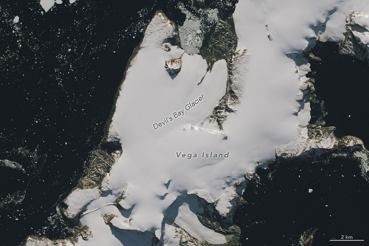
NASA’s Earth Observatory has published two Landsat 9 images of Vega Island, off the Antarctic Peninsula, where ice and rock form a grinning skull in profile. The October 2026 view shows much of the snow gone and darker bare ice exposed.
A face made of ice, rock and rubble
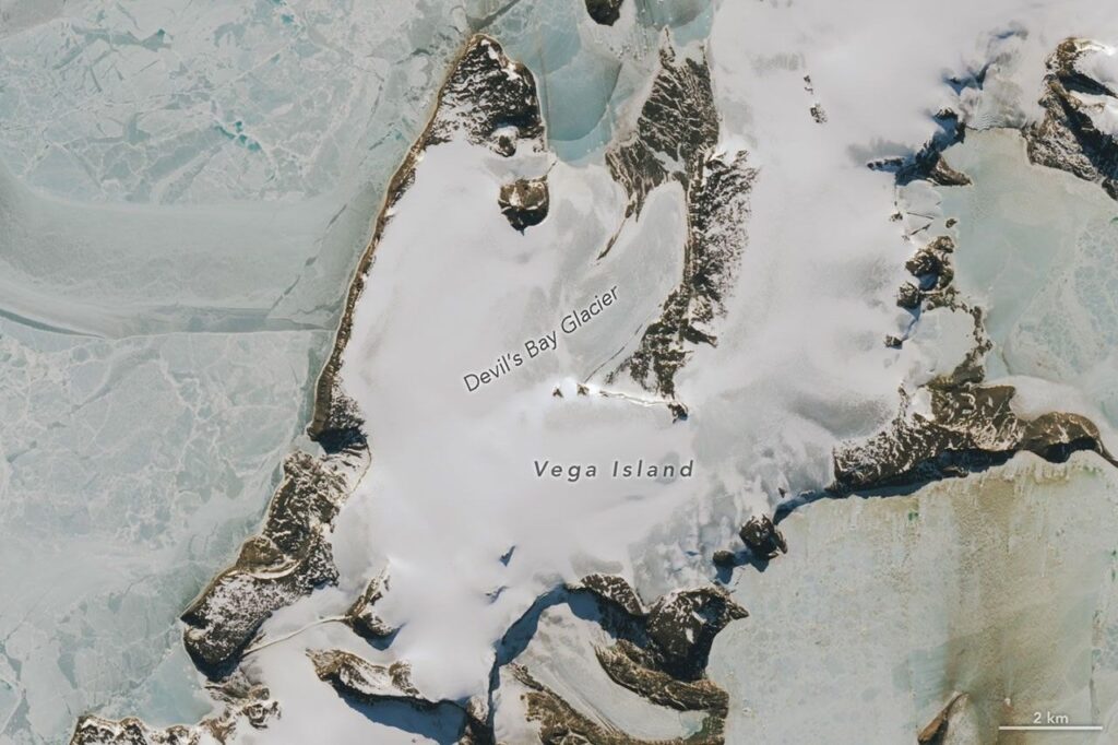
Vega Island lies in the Weddell Sea, east of the Antarctic Peninsula. According to NASA, its features combine to look like a skull facing Devil Island. A nunatak, a rocky peak sticking up through the ice, forms the eye socket. A lateral moraine, a ridge of rock debris carried along the side of a glacier, forms the mouth. Bahía del Diablo (Devil’s Bay) Glacier makes up the jawbone.
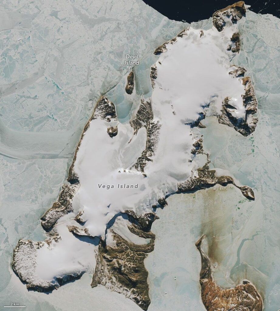
The pictures were taken by the Operational Land Imager (OLI), a camera on Landsat 9 that records sunlight reflected from the surface. One is dated March 22, 2025, at the start of austral autumn, and the other October 10, 2026, in spring. NASA notes that clouds hid the island in March 2026, so no image from that month was used.
The difference between the two is snow. In March 2025 a layer of snow coats the ice, which NASA says is typical of the region’s wettest month. In October 2026 large areas are free of snow, and the darker ice surface shows through.
A warm winter and the risk of a faster melt
NASA cites glaciologist Mauri Pelto of Nichols College, who said above-average temperatures in winter 2026, especially in June, were partly responsible for the bare ice. He said exposed ice on Vega and nearby islands points to limited new snow over the winter, made worse by sublimation (snow turning directly to vapor) and wind scouring. “The winter season was no treat for these glaciers,” Pelto said.
Bare ice matters because it is darker than snow and absorbs more of the Sun’s energy. NASA says melting is therefore poised to speed up as days grow longer and warmer. Pelto added that even a thin cover of new snow from a spring storm would help in the short run.
He also described what is at stake for the skull itself: it is preserved while buried in snow and ice, but weathers away when exposed to melt, which would change the jawline and enlarge the eye socket.
Landsat has watched these glaciers for decades
NASA says the first full map of Vega’s ice, published in 1982, drew on early Landsat data, aerial photos and topographic maps. It described four ice caps and cataloged 29 glaciers. Devil’s Bay Glacier has been closely monitored since the austral summer of 1998-1999, and researchers have measured an overall decline in its mass. Recent satellite images show ice loss on other glaciers there too, with more bedrock showing.
The island also has a place in polar history. The Swedish Antarctic Expedition of 1901-1903 split into three groups that spent a winter apart, and lost its ship to pack ice. Two of the groups met again at Cape Well-met, off the skull’s “forehead”, in spring 1903, and an Argentinean expedition rescued the survivors soon after.
Why a satellite that repeats itself is the right tool
The comparison works because Landsat covers the same ground again and again. According to NASA’s Landsat 9 mission page, the satellite launched on September 27, 2021, and revisits any spot every 16 days; paired with Landsat 8, the two observe a location about every 8 days. Each scene spans 185 kilometers (115 miles), and the OLI-2 instrument resolves 30 meters in its visible and infrared bands, fine enough to pick out a moraine or a rock outcrop on an island like Vega.
That steady record is what turns a striking picture into evidence. The science payoff is a way to check, season by season, how long snow lasts on the glaciers, because the timing of bare ice largely sets how much melt follows. Polar clouds limit the usable views, as the missing March 2026 image shows, so frequent passes raise the odds of catching a clear day. NASA’s note on Devil’s Bay Glacier also shows how satellite pictures sit alongside decades of measurements made on the ice itself.
For now, the October image is a snapshot at the start of the melt season. NASA’s text points to what to watch: whether spring snow arrives before the bare ice warms.