Satellite night lights show Isaias darkening Pensacola, and the glow back within days
NASA's Black Marble HD imagery shows lights dropping sharply around Pensacola and U.S. Route 98 after Isaias, then returning within days.

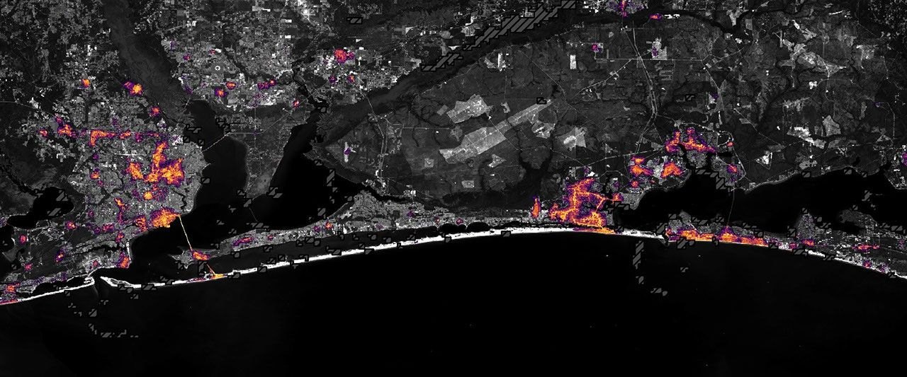
NASA’s Earth Observatory has published night-lights images of the Florida Panhandle showing sharp drops in light around Pensacola and Destin after Hurricane Isaias. By October 14, the pattern looked similar to pre-storm conditions.
What the images show
The pictures use Black Marble HD, a product built from the VIIRS instrument, a sensor on the NOAA-20 satellite. VIIRS has a day-night band, a channel sensitive enough to detect light emitted and reflected at night. NASA says the team corrected the data for changes in the landscape, the atmosphere and the phase of the Moon. It also filtered out stray light that does not come from electric lamps. The lights are laid over a Landsat 9 base map, a daytime satellite image of the same ground.
The first comparison sets a composite of August 2026, representing typical conditions, against October 11, after most of the storm’s clouds had cleared. Lights are sharply reduced around parts of Pensacola and along the U.S. Route 98 corridor toward Destin, which NASA says suggests widespread power disruptions.
Some places stayed lit. Ranjay Shrestha of NASA’s Black Marble science team pointed to Pensacola International Airport, Pensacola Christian College and parts of downtown Pensacola. NASA says the pattern could reflect backup power, differences in electrical infrastructure or areas that kept electricity during the storm, but the imagery alone cannot confirm the reason.

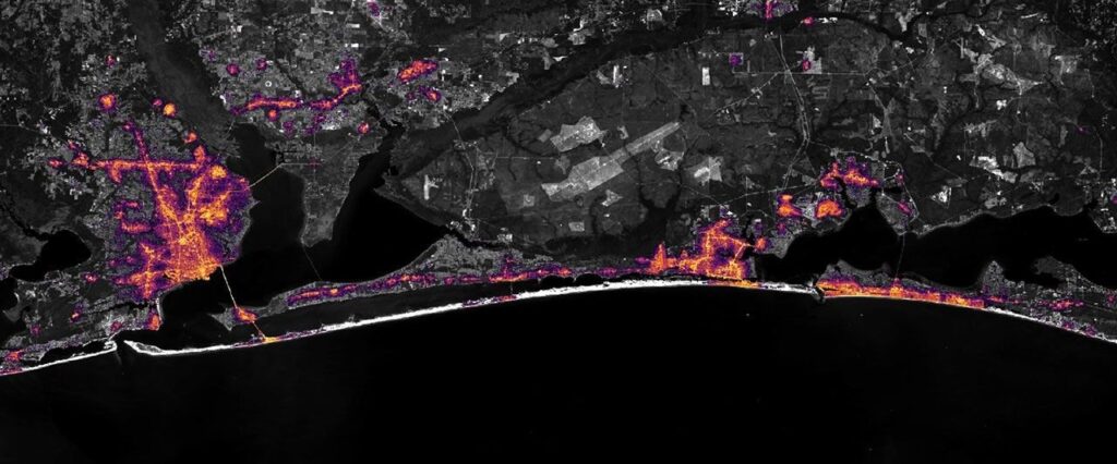
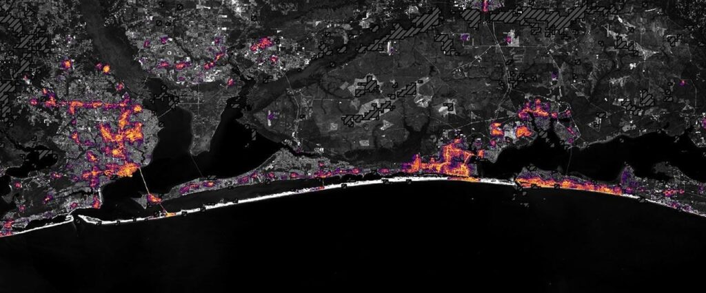
A second pair compares October 11 with October 12. By the 12th, lights had begun to return in some affected areas, according to NASA. By October 14, two days later, the lighting looked similar to before the storm.
The storm behind the outages
According to NASA, Isaias became the first hurricane of the 2026 Atlantic season on October 8 after a quiet start. It came ashore close to Destin on the evening of October 9 as a Category 2 storm, with its strongest sustained winds reaching 105 mph (170 km/h). The storm brought heavy rain and flash flooding to parts of Alabama and the Florida Panhandle, and its winds toppled trees and downed power lines.
The National Weather Service recorded gusts above 100 miles per hour along a corridor west of the center, NASA says. Preliminary reports included 117 miles per hour at Oriole Beach and 102 miles per hour at Pensacola City Hall. The biggest drops in night lights overlapped that broader area west of the eye.
Shrestha said standard Black Marble imagery, available through NASA Worldview, gives a broad picture of immediate impacts. “Black Marble HD takes this a step further by allowing us to visualize these changes at a much finer spatial scale,” he said.
NASA’s Disasters Program is assisting the Alabama Red Cross and the Alabama Emergency Management Agency in their response to Isaias, working alongside FEMA and the USGS Coastal Storms Team. NASA says the team will add maps and data products to its public mapping portal as they become available.
What night-light images can and cannot tell
The images are useful, but they are not an outage map. NASA states that Black Marble complements ground-based outage reports rather than replacing them, and that the imagery cannot explain why a given spot stayed lit. A bright pixel might be a hospital generator, a restored circuit or a parking lot floodlight.
Two other limits come from the physics of the sensor. The Isaias images mark dark gray, hash-marked areas where clouds blocked VIIRS from collecting data, so no conclusion can be drawn there. NASA’s Earthdata team has also noted that bright moonlight and cloud cover complicate detection of power outages from night lights.
The method has been used before. NASA’s Earthdata team compared NOAA-20 VIIRS images from July 5 and July 9, 2024 to show dimmer lights over Houston after Hurricane Beryl. NASA Earth Observatory’s Georgia study after Hurricane Helene compared September 28, 2024, data with a pre-storm August composite. Isaias follows the same before-and-after recipe, now at a finer scale and with a third date that tracks recovery.
Shrestha said that seeing which areas are recovering and which remain dark can help responders and officials direct attention and resources to the places that need them most. The Isaias sequence suggests that, at least in the areas NASA mapped, the lights came back quickly.