A rare ‘doughnut’ typhoon and an ex-typhoon bound for Alaska: NASA shows both at once
NASA satellites caught Super Typhoon In-fa, a rare 'annular' storm, near the Mariana Islands while the remnants of Typhoon Champi, now a different kind of storm, approached Alaska.

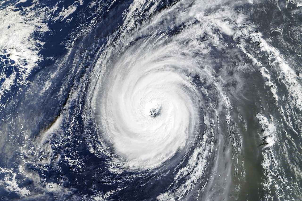
Two NASA satellites caught the Pacific’s stormy season in action. Super Typhoon In-fa, a rare storm with a nearly circular shape and a large eye, sat near the Mariana Islands on Oct. 29-30, while the remnants of Typhoon Champi closed in on Alaska, NASA’s Earth Observatory reported on Nov. 3.
One camera, two kinds of storm
The wide view above comes from EPIC, the Earth Polychromatic Imaging Camera on the DSCOVR satellite, taken on Oct. 29, 2026. It shows In-fa as a compact, round tropical cyclone in the middle of the frame, with Asia at the left edge. A long comma-shaped band of cloud curves from the high latitudes near Alaska toward the tropics.

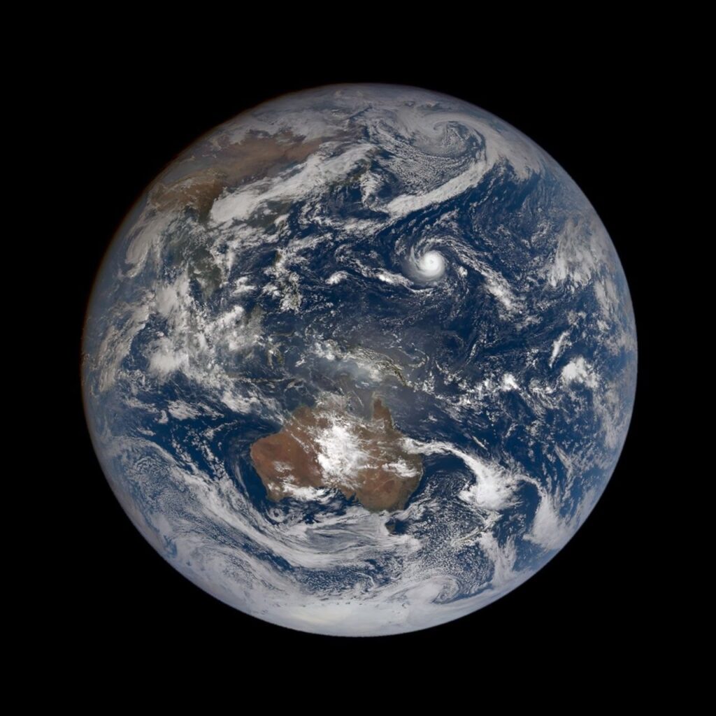
That comma is the other half of the story. A tropical cyclone has a warm center and runs on heat and moisture rising from warm seawater. After Champi weakened, it went through what meteorologists call extratropical transition: it turned into a cold-centered storm that gets its energy from the clash between warm and cold air masses, and it develops fronts and broad spiraling cloud bands. NASA said the Bering Sea storm track would probably have produced a midlatitude storm on Oct. 30 anyway, but Champi appears to have become intertwined with it and helped intensify it.
Gary Partyka, a meteorologist at NASA’s Goddard Space Flight Center, pointed to a typical sign of such a transition: the storm’s wind field spreads out. The winds do not necessarily get stronger, he said, but they cover a much larger area.

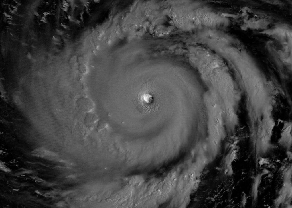
In-fa’s ‘doughnut’ eye
The second image was taken on Oct. 30 by the MODIS instrument (Moderate Resolution Imaging Spectroradiometer) on NASA’s Terra satellite, when In-fa was just west of the Mariana chain. The storm had a nearly circular outline and a large eye, the traits meteorologists use to label a subset of cyclones as annular storms. They usually lack the spiral rainbands of a standard cyclone, which is why forecasters nickname them "doughnuts" or "truck tires."
Annular storms are uncommon: one analysis cited by NASA puts them at just 4 percent of tropical cyclones in the western North Pacific. Their eyes average about 45 kilometers (30 miles) across, against about 25 kilometers for ordinary cyclones, and they tend to hold their strength longer when conditions turn unfavorable. NASA also noted that In-fa is the fifth typhoon to affect the Mariana Islands this year.
Champi’s long road to Alaska
Before its remnants reached Alaska, Champi reached maximum sustained winds of nearly 300 km/h (185 mph) and brought damaging winds and heavy rain to Taiwan, Guam, parts of China and Japan, NASA said. In Alaska, news reports described high winds and heavy rain and snow, but not the catastrophic damage that followed ex-typhoon Halong in October 2025.
Rick Thoman, a climatologist at the University of Alaska Fairbanks, noted that Champi is the fourth ex-typhoon to enter Alaskan waters this year, after Bang-Lang in August, Dujuan in September and Choi-wan in early October. The very strong El Niño years of 1997 and 2015 had three each. Roughly 60 ex-typhoons have affected the state since 1970, he said.
A season built on El Niño: How 2026 compares
El Niño is a climate pattern, recurring every two to seven years, in which parts of the equatorial Pacific run warmer than normal. NASA’s Partyka called the strong El Niño now underway a "likely contributor" to a particularly active year. Some experts say it makes Northwest Pacific storms curve north rather than carry on west to East Asia and Southeast Asia, which sends more of them toward Guam, the Northern Mariana Islands, Japan and the Korean Peninsula.
NASA’s own earlier coverage this year shows how the pattern has played out. Super Typhoon Bavi, the third Category 5 cyclone of 2026, peaked near the Marianas on the night of July 5 with winds of 290 km/h (180 mph) over water about 30 degrees C (86 degrees F), then crossed the islands and Guam, according to NASA’s Bavi report. It was the second powerful typhoon to cross the islands in about three months, after Sinlaku in mid-April. The article quoted meteorologist Jeff Masters of Yale Climate Connections, who said storms in El Niño years may form farther east, giving them more time over warm water and "a greater chance of reaching Category 5 intensity."
The effects reach beyond the western Pacific. NASA’s account of Hurricane Lala in August says El Niño had been underway since mid-June. Lala passed just south of the Island of Hawaii on Aug. 15 as a Category 1 hurricane, yet the highest rainfall total, at Laupahoehoe, reached 43.55 inches (110.6 centimeters) by the morning of Aug. 17. NASA noted that the Atlantic hurricane season stayed relatively calm in the same period.
Put side by side, the numbers show the season’s range: a 4 percent oddity like In-fa, a near-300 km/h Champi, and four ex-typhoons in Alaskan waters against three in the two strongest El Niño autumns NASA’s source cites. Twenty-five named storms have formed in the Northwest Pacific since April, according to the Earth Observatory.