Sentinel-6B starts operational service, extending the sea-level record past 30 years
EUMETSAT says the Copernicus satellite is now in operational service, continuing the global sea-level record begun in 1992 and feeding weather and ocean forecasts within hours.

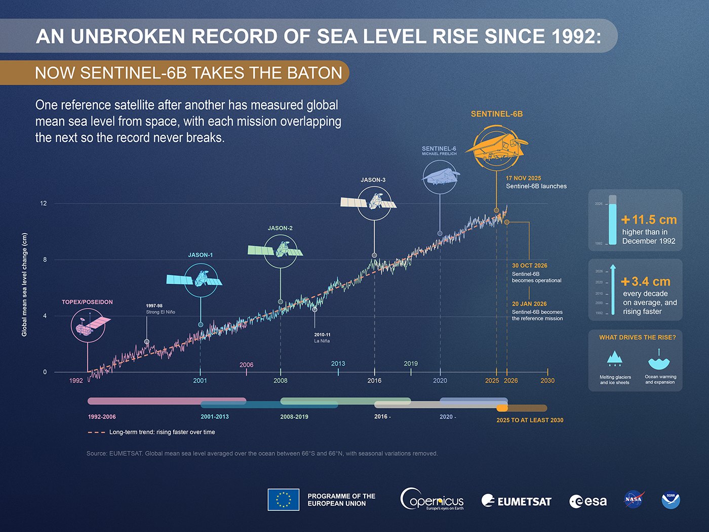
The Copernicus Sentinel-6B satellite entered operational service on 30 October 2026, EUMETSAT announced. Its data keep a satellite record of global sea level, begun in 1992, running into the 2030s.
EUMETSAT, Europe’s meteorological satellite agency, operates the spacecraft for the European Commission. It says Sentinel-6B will soon become the world’s reference satellite for high-precision ocean altimetry, meaning the mission against which other sea-level satellites are calibrated. Altimetry is the measurement of the height of the sea surface by bouncing radar pulses off it from orbit.


A twin flying 30 seconds behind
Sentinel-6B has a twin, Sentinel-6 Michael Freilich, which launched in November 2020. Since December 2025 the two have flown in tandem at 1,336 km, 30 seconds apart. Because both measure almost the same patch of ocean, scientists can compare the readings and calibrate the newer satellite against the proven one.
Within a few months, EUMETSAT expects the international community to designate Sentinel-6B as the benchmark. At that point its twin will shift to a different orbit, which ends the formation flight and widens the area the pair can observe. Together they will measure sea level over as much as 95% of the ocean not covered by ice, and will also record currents, wave heights, wind speeds and the water levels of rivers and lakes.

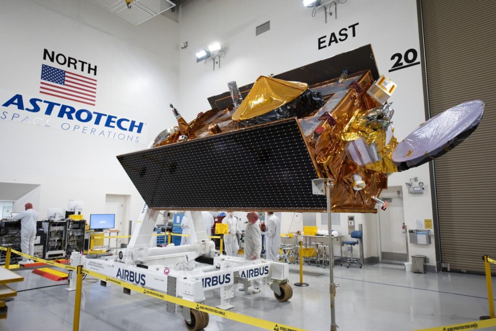
An onboard radio occultation instrument studies how radio signals bend while crossing the atmosphere, which yields temperature and water-vapour profiles. A high-resolution mode on both satellites gives detailed readings near coastlines and over inland waters. EUMETSAT flies the satellites round the clock, and users receive the data roughly three hours after measurement.
An ocean surface more than 11.5 cm higher than in 1992
The record Sentinel-6B continues began with TOPEX/Poseidon and the Jason series, a long collaboration between European and US partners. According to EUMETSAT, the global ocean surface now stands more than 11.5 cm above its December 1992 level. The pace is speeding up: 2.8 cm in the first decade, and as much as 4.0 cm over the most recent one. Meltwater from glaciers and ice sheets drives the rise, together with the expansion of seawater as it warms.
EUMETSAT Director-General Phil Evans said that “No other technology can follow changes in sea level across the whole globe as consistently as satellite altimetry.”
Who relies on the data, from ship captains to coastal planners
The practical users are weather services, shipping and coastal authorities. Hours after collection, the measurements enter forecast models used to predict rough seas in Atlantic winter storms and Mediterranean cyclones, and to estimate how intense hurricanes will become. Seasonal forecasts of El Niño and La Niña, the warm and cool swings of Pacific waters that shift weather worldwide, also draw on the sea-level record.
Copernicus ocean forecasts show major currents and waves, and ships change course depending on where those lie. The Copernicus climate services use the same observations to monitor long-term change in the ocean. Evans said around 900 million people live in low-lying coastal areas worldwide, and that the weather and ocean services of EUMETSAT’s member states depend on Sentinel-6 data for protecting communities, infrastructure and ecosystems.
The mission’s size and longevity matter beyond Europe. According to ESA, each Sentinel-6 satellite carries a Poseidon-4 radar altimeter and flies in an orbit inclined 66 degrees to the equator, which is what lets the pair cover most of the open ocean. Sentinel-6B launched on 17 November 2025 on a SpaceX Falcon 9 from Vandenberg, California, and ESA says the Sentinel-6 mission extends sea-surface height measurements until at least 2030. ESA also gives the current rate of sea-level rise as 3.2 mm per year, which shows why a record without gaps is needed: a change of a few millimeters a year is only visible against decades of consistent data.
The satellite is run by EUMETSAT for the European Commission, together with ESA, NASA and the US National Oceanic and Atmospheric Administration, and with support from France’s space agency CNES. EUMETSAT also points to its role alongside Copernicus Sentinel-3 altimetry and wind and atmospheric data from its Metop satellites.