

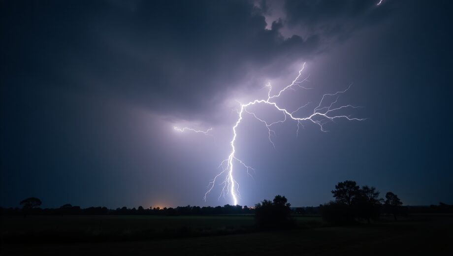
Lightning never fails to amaze me — it’s this brilliant, powerful spark of nature that lights up the sky and sometimes stretches for unbelievable distances. Recently, I came across some fascinating news from the World Meteorological Organization (WMO) that highlights just how extreme lightning can get. The WMO certified a new world record for the longest single lightning flash, measuring an astonishing 829 kilometers (515 miles) across a storm system in the United States.
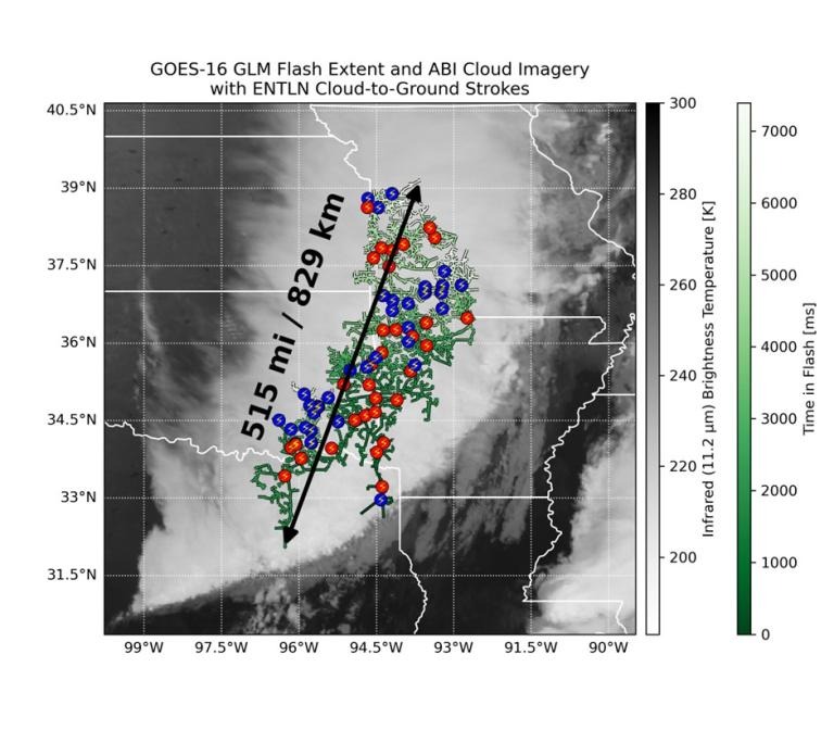
This record-breaking megaflash, which was detected back in October 2017 but only recently verified, stretched from eastern Texas all the way near Kansas City, Missouri — a distance roughly equivalent to traveling from Paris to Venice in Europe. To put it in perspective, a car trip that long would take about 8 or 9 hours, and a commercial flight around 90 minutes. It’s just mind-boggling that a single continuous lightning flash could cover such a vast distance in the atmosphere.
Lightning is both a breathtaking spectacle and a serious hazard, making early warnings a critical focus for public safety worldwide.
The hidden science behind these megaflashes
The WMO record-breaking flash comes from an area known as the Great Plains in the US, a well-documented hotspot for massive storm systems called Mesoscale Convective Systems (MCS). The unique dynamics of these storms allow lightning to leap across incredibly long distances in what’s called a megaflash. Interestingly, the previous record for the longest lightning flash was also set in this region, which tells us a lot about how the environment there supports these dramatic events.

One thing I found really interesting is that this 2017 event wasn’t identified as a record breaker immediately. It was discovered after reanalyzing data from NOAA’s advanced geostationary satellite GOES-16, equipped with a lightning mapper that continuously monitors flashes from space. This latest technology has revolutionized how we study lightning, enabling scientists to detect flashes spanning hundreds of kilometers — way beyond what ground-based lightning networks could observe reliably before.
As one expert recently explained, this record demonstrates both the incredible power inherent in natural weather systems and the leaps we’ve made in measuring and understanding these electrical marvels using space-based observatories. And it’s thrilling to realize that we might still find even more extreme lightning flashes as satellite data grows richer.
Why this matters beyond the awe
Lightning isn’t just spectacular; it’s a serious hazard, responsible for injuries, deaths, wildfires, and disruptions — especially in aviation. The WMO made it clear that understanding megaflashes is key to improving early warning systems worldwide. Lightning can travel surprisingly far from its parent storm clouds, posing risks that might catch people or pilots off guard. These so-called “bolt from the gray” flashes can strike hundreds of kilometers away from the main storm, emphasizing the need to take lightning safety seriously no matter how far away the storm may seem.
Safety advice remains straightforward but crucial: the safest places during a lightning event are substantial structures equipped with wiring and plumbing or fully enclosed, metal-roofed vehicles. Beaches, bus stops, motorcycles, and open shelters just don’t cut it. This new record underlines how quickly lightning hazards can develop and travel, reinforcing the urgent need for reliable, accessible warning systems.

From satellite tech to a growing archive of extreme weather
What thrills me most about this discovery is the role of cutting-edge satellite technology in unveiling a layer of our atmosphere’s activity previously hidden from view. Geostationary Lightning Mappers (GLMs) on satellites like GOES-16 watch vast regions continuously, enabling scientists to spot long-distance lightning flashes as they happen.
It’s also part of a broader effort by the WMO to maintain detailed archives of extreme weather phenomena worldwide—from temperature and rainfall to hail, wind, and now lightning extremes. This systematic approach helps improve our understanding of weather risks and informs safety measures and climate research.
Interestingly, the WMO archive already holds some jaw-dropping lightning records, like the longest duration flash lasting over 17 seconds in South America and tragic high-casualty strikes in Africa. These extremes remind us how vital ongoing research and preparedness are.

Key takeaways from the megaflash record
- Lightning can travel extraordinary distances, as proven by the 829 km megaflash, setting a new world record.
- Advanced satellite lightning mappers are transforming how we detect and study these megaflashes, revealing phenomena that ground systems couldn’t capture.
- Understanding megaflashes and their risks is critical for public safety, especially with phenomena like “bolt from the gray” strikes that can hit far from storms.
- The safest places during lightning are sturdily built, wired buildings or fully enclosed metal vehicles; open shelters and open-air venues are unsafe.
- WMO’s comprehensive archive of weather extremes plays a crucial role in documenting and analyzing these phenomena, helping societies better prepare for natural hazards.
Reflecting on the power and mystery of lightning
Learning about this record-breaking lightning megaflash made me appreciate how dynamic and powerful our atmosphere truly is. The ongoing advancements in satellite technology not only push the boundaries of scientific discovery but also equip us with better tools to keep people safe. Lightning remains one of nature’s most awe-inspiring forces – a dazzling display of raw energy that commands respect and attention.
From the sweeping plains of the US Great Plains to the skies above our cities and countryside, the skies can hold surprises of immense scale, waiting for us to uncover their secrets. And thanks to global collaborations and technological leaps, we’re getting better every day at witnessing and understanding these spectacular natural phenomena.